
File:India railways1909a.jpg
本预览的尺寸:719 × 600像素。 其他分辨率:288 × 240像素 | 575 × 480像素 | 921 × 768像素 | 1,227 × 1,024像素 | 1,322 × 1,103像素。
原始文件 (1,322 × 1,103像素,文件大小:336 KB,MIME类型:image/jpeg)
摘要
| 描写 |
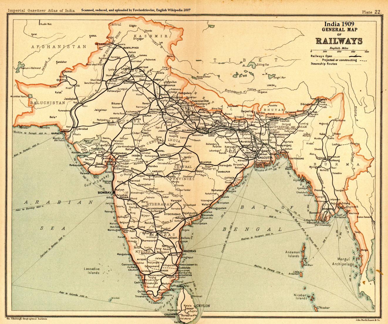
English: A general map of Indian railways, 1909. Scanned and reduced from personal copy of Imperial Gazetteer of India, volume 25
(Atlas), Oxford University Press, 1909, by Fowler&fowler«Talk» 05:05, 18 September 2007 (UTC) |
|||||||||
| 日期 | ||||||||||
| 来源 | Imperial Gazetteer of India, 1909 | |||||||||
| 創作作者 |
John Bartholomew and Company/Edinburgh Geographical Institute |
|||||||||
| Geotemporal data | ||||||||||
| 边框 |
|
|||||||||
| 地理参考 | ||||||||||
许可协议
這一創作於英國管轄區內的作品現在位於公有領域。
其原因是以下之一:
HMSO已經宣布,皇家版權到期適用於全世界範圍(參考:HMSO Email Reply)
|
 |
原始上传日志
原始描述頁面位於這裡。下列使用者名稱均來自en.wikipedia。
- 2007-09-18 05:05 Fowler&fowler 1322×1103× (344309 bytes) Scanned and reduced from personal copy of Imperial Gazetteer of India, volume 25 (Atlas), Oxford University Press, 1909, by ~~~~ {{PD-US-1923-abroad}}
文件历史
点击某个日期/时间查看对应时刻的文件。
| 日期/时间 | 缩略图 | 大小 | 用户 | 备注 | |
|---|---|---|---|---|---|
| 当前 | 2010年10月24日 (日) 17:32 | | 1,322 × 1,103(336 KB) | File Upload Bot (Magnus Manske) | {{BotMoveToCommons|en.wikipedia|year={{subst:CURRENTYEAR}}|month={{subst:CURRENTMONTHNAME}}|day={{subst:CURRENTDAY}}}} {{Information |Description={{en|Scanned and reduced from personal copy of Imperial Gazetteer of India, volume 25 (Atlas), Oxford Unive |
文件用途
全域文件用途
以下其他wiki使用此文件:
- ar.wikipedia.org上的用途
- ast.wikipedia.org上的用途
- as.wikipedia.org上的用途
- bn.wikipedia.org上的用途
- ca.wikipedia.org上的用途
- de.wikipedia.org上的用途
- en.wikipedia.org上的用途
- Rail transport in India
- History of rail transport
- Indian Railways
- North Western Railway zone
- History of science and technology on the Indian subcontinent
- Economic history of India
- Northern Railway zone
- North Central Railway zone
- North Eastern Railway zone
- Kathgodam
- Thar Express
- British Raj
- User:Fowler&fowler
- User:Fowler&fowler/Short History Indian Independence Movement
- Economy of India under the British Raj
- History of the British Raj
- User talk:Nichalp/Archive66
- Portal:Trains/Did you know/February 2009
- History of Bareilly
- Economic history of Pakistan
- Indian reunification
- Talk:British Raj/Archive 8
- Palwal railway station
- Rail transport in Haryana
- User:Feroze Ahmad 2/sandbox4
- User:AustinJAragon/sandbox
- User:Frank.p873/sandbox
- User:Efrain805/British Raj
- User:AustinJAragon/British Raj railway section
- User:Falcaorib/India and Pakistan
- es.wikipedia.org上的用途
查看此文件的更多全域用途。