
File:Deepwater Horizon oil spill - May 24, 2010 - with locator.jpg

原始檔案 (2,118 × 1,628 像素,檔案大小:385 KB,MIME 類型:image/jpeg)
摘要
|
| 描述 |
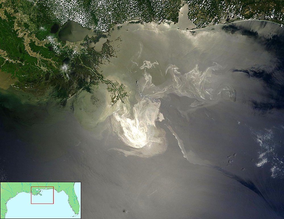
English: Description from NASA (source):
"NASA's Terra Satellites Sees Spill on May 24 Sunlight illuminated the lingering oil slick off the Mississippi Delta on May 24, 2010. The Moderate-Resolution Imaging Spectroradiometer (MODIS) on NASA’s Terra satellite captured this image the same day. Oil smoothes the ocean surface, making the Sun’s reflection brighter near the centerline of the path of the satellite, and reducing the scattering of sunlight in other places. As a result, the oil slick is brighter than the surrounding water in some places (image center) and darker than the surrounding water in others (image lower right). The tip of the Mississippi Delta is surrounded by muddy water that appears light tan. Bright white ribbons of oil streak across this sediment-laden water. Tendrils of oil extend to the north and east of the main body of the slick. A small, dark plume along the edge of the slick, not far from the original location of the Deepwater Horizon rig, indicates a possible controlled burn of oil on the ocean surface. To the west of the bird’s-foot part of the delta, dark patches in the water may also be oil, but detecting a manmade oil slick in coastal areas can be even more complicated than detecting it in the open ocean. When oil slicks are visible in satellite images, it is because they have changed how the water reflects light, either by making the Sun’s reflection brighter or by dampening the scattering of sunlight, which makes the oily area darker. In coastal areas, however, similar changes in reflectivity can occur from differences in salinity (fresh versus salt water) and from naturally produced oils from plants. Michon Scott NASA's Earth Observatory NASA Goddard Space Flight Center"
Français : Traduction partielle de la description par la NASA(source): La marée noire causée par l'incendie de la plateforme pétrolière Deepwater Horizon vue par le satellite Terra, de la NASA, le 24 mai 2010.
Cette image a été acquise par le Moderate-Resolution Imaging Spectroradiometer (MODIS, pour Spectroradiomètre d'imagerie à résolution moyenne), embarqué sur le satellite Terra. Le pétrole lisse la surface de l'océan, ce qui la rend plus claire là où elle réfléchit le soleil (par exemple, au centre de la photo) et plus sombre ailleurs (par exemple en bas à droite). Le delta du Mississippi est visible en haut, entouré d'eaux saumâtres et boueuses qui apparaissent en brun, rayé de rubans argentés de pétrole. |
|||||
| 日期 | ||||||
| 來源 |
1/ File:Deepwater Horizon oil spill - May 24, 2010.jpg (based upon Original image with cropping) 2/ Locator by FT2 from File:Map of USA topological.png (Public domain by author demis.nl). |
|||||
| 作者 | NASA/GSFC, MODIS Rapid Response AND demis.nl AND FT2 | |||||
| 授權許可 (重用此檔案) |
Combined with other public domain source imagery. I as compositor of these two public domain images also release my work into the public domain - FT2 |
|||||
| 其他版本 |
|


檔案歷史
點選日期/時間以檢視該時間的檔案版本。
| 日期/時間 | 縮圖 | 尺寸 | 用戶 | 備註 | |
|---|---|---|---|---|---|
| 目前 | 2010年6月19日 (六) 00:10 | | 2,118 × 1,628(385 KB) | FT2 | {{Information |Description={{en|1=to add}} |Source=to add |Author=to add |Date=2010-01-01 |Permission={{PD}} |other_versions=Deepwater Horizon oil spill - May 24, 2010.jpg }} |
檔案用途
下列2個頁面有用到此檔案:
全域檔案使用狀況
以下其他 wiki 使用了這個檔案:
- ar.wikipedia.org 的使用狀況
- ast.wikipedia.org 的使用狀況
- bg.wikipedia.org 的使用狀況
- ca.wikipedia.org 的使用狀況
- de.wikipedia.org 的使用狀況
- en.wikipedia.org 的使用狀況
- en.wikibooks.org 的使用狀況
- en.wikinews.org 的使用狀況
- en.wikiquote.org 的使用狀況
- es.wikipedia.org 的使用狀況
- fr.wikipedia.org 的使用狀況
- gl.wikipedia.org 的使用狀況
- he.wikipedia.org 的使用狀況
- hu.wikipedia.org 的使用狀況
- it.wikipedia.org 的使用狀況
- ja.wikipedia.org 的使用狀況
- ko.wikipedia.org 的使用狀況
- krc.wikipedia.org 的使用狀況
- lv.wikipedia.org 的使用狀況
- ml.wikipedia.org 的使用狀況
- ms.wikipedia.org 的使用狀況
- my.wikipedia.org 的使用狀況
- pt.wikipedia.org 的使用狀況
- th.wikipedia.org 的使用狀況
- tr.wikipedia.org 的使用狀況
- Vikipedi:Seçkin resimler/Uzay/Dünya'ya bakış
- Vikipedi:Günün seçkin resmi/Şubat 2012
- Deepwater Horizon petrol sızıntısı
- Vikipedi:Seçkin resim adayları/Deepwater Horizon oil spill - May 24, 2010 - with locator.jpg
- Vikipedi:Seçkin resim adayları/Arşiv/Mart 2011
- Kullanıcı:Ahzaryamed/arşiv-06.11.2010-21.04.2011
- Şablon:GSR/2012-02-04
- Vikipedi:Seçkin resimler/Ana sayfaya çıkmış resimler/2012 listesi
- Vikipedi:Seçkin resimler/Ana sayfaya çıkmış resimler/2014 listesi
- Vikipedi:Günün seçkin resmi/Mayıs 2014
- Şablon:GSR/2014-05-13
- Şablon:GSR/2017-03-26
檢視此檔案的更多全域使用狀況。